The St. Olaf College contribution to the US-ITASE program is a deep-penetrating
radio echo-sounding system that can measure the bedrock surface beneath the
ice as well as internal layers that have unique electrical properties.
Total ice thickness data is useful to researchers who develop ice-flow models
of the ice sheet. The immense size of the ice sheet makes it difficult
to obtain high-accuracy thickness measurements over the entire continent.
The long distance traverses of the US-ITASE program make it an ideal platform
for ground-based radar measurements.
Internal ice reflections are usually related to deposition of volcanic debris
(acids or ash) or dust layers. These layers give researchers a window
into the accumulation and flow history of the ice sheet. Changes in the
layer thickness along the traverse routes may be attributed to changes in snow
accumulation due to climate or geographic changes (crossing a drainage divide,
for example). Changes in the ice flow velocity due to bumps in the bedrock
or changes in the bedrock character cause the ice to thicken or thin as the
ice decelerates or accelerates.
Numerous publications and presentations resulted from the radar work conducted
during the US-ITASE program. The following is a list of published manuscripts
and abstracts. Additional presentations were made at WAIS Initiative and Midwest
Glaciology meetings without published abstracts.
Welch, B.C. and R.W. Jacobel, Bedrock topography and wind erosion sites in
East Antarctica, observations from the 2002 US-ITASE traverse. Annals of Glaciology,
(in press).
Jacobel, R.W. and B.C. Welch, A time marker at 17.5 kybp detected throughout
West Antarctica. Annals of Glaciology, (in press).
Jacobel, R. W., B. C. Welch, E. J. Steig, and D. P. Schneider, 2005, Glaciological
and climatic significance of Hercules Dome, Antarctica: An optimal site for
deep ice core drilling, J. Geophys. Res., 110, F01015, doi:10.1029/2004JF000188
(PDF).
Siegert, M.J., Welch, B., Morse, D., Vieli, A., Blankenship, D.D., Joughin,
I., King E.C., Leysinger Vieli, G.J.M.C., Payne, A.J., Jacobel, R., 2004,
Ice flow direction change in interior West Antarctica, Science, 305, 1948-1951
.
Welch, B.C., S.A. Arcone, R.W. Jacobel, M. Helgen, 2004, Shallow (400-MHz)
and deep (3-MHz) radar used to image wind erosion features in East Antarctica,
Eos Trans. AGU, 85(47), Fall Meet. Suppl., Abstract C43A-0222.
Welch, B.C., and R.W. Jacobel, 2003, Analysis of Deep-Penetrating Radar Surveys
of West Antarctica, US-ITASE 2001, Geophys. Res. Lett., 30(8), 1444, 10.1029/2003GL017210
(PDF).
Welch, B.C., R.W. Jacobel, K. Christianson, K. Coffel-Dwyer, 2003, Interactions
Between Large Bedrock Features and Ice Sheet Dynamics Interpreted From Deep-Penetrating
Radar Along the US-ITASE Traverse Routes, Eos Trans. AGU, 84(46), Fall Meet.
Suppl., Abstract C21D-02 Invited.
Jacobel, R.W., B.C. Welch, M.T. Bills, T.J. Engle, 2003, Ground-Based Deep-Penetrating
Radar Studies Along The US-ITASE Traverse, Eos Trans. AGU, 84(46), Fall Meet.
Suppl., Abstract C21A-08 Invited.
Jacobel, R.W., B.C. Welch, M.P. Helgen, L.S. Smith, 2003, Hercules Dome -
An Overview From the US-ITASE Deep Radar, Eos Trans. AGU, 84(46), Fall Meet.
Suppl., Abstract C11C-0825.
Welch, B.C., R.W. Jacobel, S.F. Harris, L.S. Smith, 2002, Analysis of 2001
US-ITASE traverse deep-penetrating radar studies in West Antarctica, Eos Trans.
AGU, 83(47), Fall Meet. Suppl., Abstract C15A-0924.
Welch, B.C., R.W. Jacobel, P. Pearson, 2002, Ice thickness and internal ice
stratigraphy along the 2001 US-ITASE traverse route measured by ground-based
radio echo-sounding, Eos Trans. AGU, 83(19), Spring Meet. Suppl., Abstract
A41A-02.
Welch, B.C. and R.W. Jacobel, 2001, Radar studies of bedrock and internal
stratigraphy along ITASE traverse routes, Eos Trans. AGU, 82(20), Spring Meet.
Suppl., Abstract OS52A-03.
We operate a 3 MHz radio echo-sounding system to transmit and receive radio
waves through as much as 3 km of ice. This signal frequency translates
to a wavelength of about 56 m in ice. The transmitter (made by the University
of Washington) emits pulses at frequency of 250 Hz. The pulses are emitted
by our transmitter antenna, a 40 m dipole dragged along the snow surface.
135 m in front of the transmitter is an identical dipole antenna that receives
the signal. The signal is amplified and passed on to an oscilloscope board
mounted directly on a field-hardened PC computer. The scope board identifies
the incoming signal, digitizes it, and sends it to the computer to be stored
on the hard drive. The scope board is extremely fast, sampling the signal
at up to 100 million samples/second. Each sample of the signal is digitized
to a 14-bit number meaning that the board is capable of processing up to 1.6
Gigabytes of signal data every second!
Fortunately we don't record data at such a fast rate, but use the board's speed
to stack the incoming signal to remove much of the environmental radio noise
that hides our reflected signal. We stack the data by averaging a few
thousand of the transmitter pulses and their resultant echoes from the bedrock
and internal layers. The traverse train travels at about 12 km/hr so we
generally stack 1200-1500 traces every 10-12 meters. Stacking and the
fast scope board allow us record a dense profile of traces while eliminating
much of the noise that would make the data difficult to process and interpret.
Our radar system operates primarily during the traverses between ice coring
sites. The system and operator are towed as the very last sleds in the
traverse train to eliminate radio noise from other instrumentation or reflections
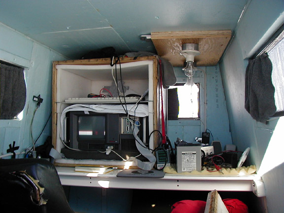
from the metal sleds and equipment. The receiver and operator are housed
in a small shelter built on a wooden Komatik sled. The shelter protects
the computer and operator from wind, cold, and snow. Power for the receiver
is provided by a small gas-powered generator mounted on the back of the sled.
The generator also provides power for battery chargers necessary to keep the
battery-powered transmitter running. The shelter is also equipped with
a GPS receiver to locate the data points. A survival bag is strapped to
the front of the shelter in case of emergency.
The transmitter is towed 100 m or more behind the receiver sled. The
transmitter and its battery sit in a small sled and are protected from the elements
by the sled's nylon cover. The antennas for the transmitter and receiver
are housed in strong hydraulic hoses and tied to the tow ropes to keep the antennas
as straight and parallel as possible.


